Our Baltic - "Mare Nostrum"
The maritime culture in general has also had a strong streak of universalism in it, at least in the Early Modern Times, which makes for pro table comparisons with, above all, the North Sea. I guess what little is common in the Baltic Sea area, is mostly maritime in nature!
The maritime aspect needs to incorporate the entire area, not just fragments of it, due to the potential of connectivity across it. There are very few efforts to do so, and if they do exist as exceptions, they use a source material that is limited in the maritime sense, either period-wise, socially or regionally. Of course, we are in possession of a large amount of older material. For instance, a politicized, but valuable reference for research from a German horizon before WWII, is still Otto Kunkel.
For the Mediterranean, we possess a prototype for an overview of a period, but this carries along far larger time perspectives, back to Classical Antiquity, i.e. Fernand Braudel, also referred to as a shining achievement by David Kirby. Compare preferably with the works by Sarah Arenson, Peregrine Horden and Nicholas Purcell, which explicitly is a comment to Braudel, and lastly, David Abulafia. However, even in the differing Mediterranean approaches we find an overwhelming dependence on either historical sources or on (seldom) archaeological ones. The Braudel prototype also serves Johan Rönnby, who successfully tries to o er another perspective of la longue durée, by placing the archaeology of human ecology in the archipelagoes of the north central Baltic in focus. Nevertheless, if there are compatible and comparable perspectives of the entire Baltic to be applied, the same kind of material must be used as sources throughout the periods in concern – historical as well as pre-historical.
History and archaeology
In addition to archaeology, historical overviews are valuable for certain other purposes. The reason is their material, although lop-sided as written socially “from above.” They summarize tendencies of political and economic factors of concern for the dominant groups. It is easier for an historian to concentrate on records of administrative procedures in shipping, and thereby unwittingly to contribute to a picture of only large-scale types of communication. This may lead to an “individualized” pattern of trade and politics. Even during the strictly speaking historical period, “everyday” maritime life in small-scale shipping, exchange, fishing, and hunting, is often under-communicated in such records. However, some narrative hints are invaluable, e.g. the works of Olaus Magnus at the end of the Middle Ages.
An archaeological perspective should above all try to be different, due to its material sources, and rediscover traces of other types and aspects of human life. In this case, I want to refer in particular to ship and harbour (of all types, also natural havens) archaeology in a statistical manner (not only individual sites), and thus –in contrast to the historical sources– to give an “anonymous”, but successively more representative picture of small-scale shipping, maritime hunting and fishing. This does definitely not exclude the cognitive aspects of modern archaeology. On the contrary, they should be made obligatory.
Such a concerted effort has never been made on the Baltic, despite the explosion of contacts and several salient texts after Die Wende in about 1989-92. For instance, I remember participating in a Lund conference in 1991 and another in Bornholm in 1992, dedicated to the same contacts across the Baltic. This tiny text does not claim to be even pioneering in this sense, but it should hopefully serve as an inspiration for the future.
Of course, this above is a very superfluous generalization of the relationship between history and archaeology in a maritime sense. There are indeed “anonymous” fragmentary statistics for certain periods, even during the Middle Ages, mostly for urban contexts (e.g. records of Lübeckian customs). However even then the scope is very limited.
Origins
Thus, it is not at all so that “we” all shared a lot of cultural elements during the time that will be in focus in the given article, but some of “us” did indeed. You will probably see that what I originally had omitted, which is a lot, would rather strengthen my argument. In particular, I tried to keep to what probably had a maritime function in one way or another. These elements could have something to do with shipping (boat and ship finds, sailing marks, harbours/ havens), with the ship as a symbol (rock carvings, ship settings, boat graves) or with a clearly coastal distribution (burial cairns, stone mazes). None of these cover the whole area of the Baltic Sea. On the contrary, they tend to be considered more or less culture-specific. Although these maps are always the product of a time-bound source-finding process in our time, the general idea probably would be the same also with extended knowledge in the future.
Some of the omissions concern the diffusion and dynamics of language. The area contains at least nine main languages and a corresponding number of recognized minority languages. This diversity dissolves into two families of tongues, which are commonly considered as not related to each other, the Indo-European one, dominant in Europe as a whole, with Germanic, Baltic and Slavonic as the groups of interest here, and the Finno-Ugrian family (Baltic Finnish, with Finnish and Estonian, and Saami in the North). An alternative, but controversial way of looking at language contact, interference and loan-words in the central part of the Baltic was in fact indicated by an archaeologist, Gösta Bågenholm.
Archaeological and DNA analyses seem to suggest an original immigration of Palaeolithic hunter-gatherers and fishermen to the Baltic area after the Ice Age from two centres. One is the Franco-Iberian cluster, the other approximately Ukraine. The rapid penetration of the entire Norwegian coast could not have happened without boats, but some kinds of vessels must anyway have existed in the whole area. It is obvious, however, that no fragments of these boats have been found, except in the very south. It is curious that finds of log boats from the Mesolithic have only been found in the southern Baltic (Denmark c. 5000 BC), and still older in the Netherlands and further south on the continent. The entire north and east of the Baltic area lacks them completely. Datings of log boats only concern the later period. Does this speak for skin boats, as has been the general idea for Norway and the rest?
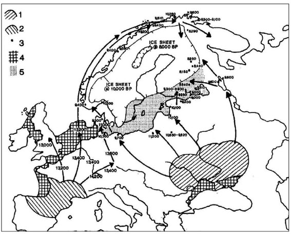
Already about 10 000 BC, there may thus have been pioneers in the neighbourhood of the North Cape, coming from at least three contemporary directions, one by way of Norway, one across Sweden and another in the Finnish northwest. Their descendants were also left on that road.
One of the salient hypotheses of the spread of Indo-European languages relates it to the slow penetration or adoption of agricultural pursuits in Europe during a period of at least 4000 years from Asia Minor to the Baltic, pioneered not by a linguist, but by a prominent archaeologist, Colin Renfrew. Other former language families were entirely superseded, except by the Basque language close to the Pyrenees and the Cantabrian mountain range of Spain, the Etruscan in Italy (extinct) and possible Baltic Sea Finnish (later to become Finnish and Estonian).
The crossing of the elements of the first agricultural pursuits from the Southern Baltic to Scandinavia occurs gradually around 3000 BC (within the Ertebølle culture). It is interesting to note the reluctant adoption of agriculture in these southern parts of Scandinavia. After an initial adaptation to agricultural pursuits there even seems to occur a reversal in certain groups to hunting and fishing, by way of the coastal seal-hunting Pitted Ware culture (Sweden, parts of Norway, and Denmark), in its lifeways comparable to what is known as the Comb-Ceramic groups of Finland and further east.
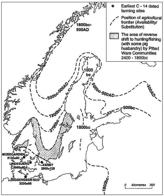
However, agriculture was not adopted in the Eastern approaches to the Baltic (Carelia etc.) until ca AD 500, perhaps indicating an original presence from the Mesolithic of a Proto-Finno-Ugrian stratum in this region. Is what we see perhaps a far-reaching continuity, in life styles as well as in linguistics?
A tendency, which may be of long standing in the Baltic Sea area, is thus the differing approaches – from reluctant acceptance to, in fact, some extent successful resistance – to basic continental impulses, in our time often called “Europeanization”. Two main factors are, as mentioned, the introduction of agriculture, which was treated in the keynote to some extent, and another, the exceedingly slow (and intermittent) introduction and spread of Catholic and Greek-Orthodox Christianity, which was not treated, just mentioned in my keynote.
This presentation exposes briefly some of the manifoldness and the versatility of the area and its human resources. This manifoldness is, I believe, a great advantage both to the interaction of the future, and to the study of history, in “a kind of northern version of the Mediterranean”. However, is the Baltic Sea not a uniquely valuable context in its own right, without reference to a much larger and traditionally more prestigious area?
Names
As we know, the maritime positioning in the Baltic differs slightly. In English, Polish, other Slavonic and Romance languages etc., we have The Baltic, Bałtyk, La (mer) Baltique – very likely the result of outsiders referring to a category of a sea “beyond the Belts” which are Store Belt and Lille Belt, channels between the Danish Islands. It was originally applied in a much more narrow sense than it is today – to a restricted area south of the Danish corridor. The modern use of concepts like Baltic, baltisch, etc., is due to a process going back to Adam of Bremen in the later part of the 11th century, and in the case of the languages of the Balts, a development in the former Russian Empire to designate its provinces south of the Gulf of Finland. This toponymic process was addressed by Josef Svennung in 1953.
To most outsiders, the Baltic Sea ends only with the Kattegat, the water area south of the justly feared point of the Skaw (Skagen) of Jutland, where the Skagerrak, named after the point, starts northward. Such classificatory divisions may have been differently applied in the past. Another dangerous point and border-line seems to have been the sandy point of Skanör south of Malmö, possibly a good reason why the Skanör promontory, former islands, was known by the Roman auctores. This spit carried the ancient Germanic name of Skaþan-auju, a warning name meaning “the island of damage”. It was of such significance that the whole of Scandinavia, originally thus Scadinavia, was named after it. The linguistic remains at the spot are still found in Skanör, Scania/ Skåne.
Other examples of names of the Baltic, some conforming to the international pattern are in Latvian Baltijas jūra, Lithuanian Baltijos jūra, but for once a direction-true Estonian Läänemeri – “the Western Sea”, then Finnish (Varsinainen) Itämeri – “the (true) Eastern Sea” (which must be due to influence from the West, most probably Sweden), Scandinavian of course Östersjön, Østersøen, (former Eystrasalt) – “the Eastern Sea”, as well as German Die Ostsee – “the Eastern Sea”. The Danish lands are still marking the pivot between the great seas up here.
There are various more regional concepts covering parts of the Baltic and the Bothnian Bay (Finnish Pohjanlahti), or parts of it in a proper manner e.g. Perämeri, Merenkurkku & Selkämeri, Ahvenanmeri – “Sea of Åland”, Saaristomeri – “Sea of Archipelagoes”, with corresponding concepts in Swedish, and the Bay of Finland, which of course is Estonian Soome laht, to Soome, Finnish Suomi, Finland (where it is Suomenlahti), and various other related names in different languages.
Each of these regions may certainly be worth a maritime archaeology or history on its own cultural merits. The conference project of maritime history called Bottnisk Contact, started by me in 1982, and mostly dealing with the Bothnian Bay, i.e. the water area north of Stockholm-Åland-Åbo (Turku), is still alive after 17 meetings with two years in-between (in 1994 we met in Tallinn).
To compare maritime positioning: in the important maritime area of the Low Countries the close varieties of seas resulted, as we know also in a Zuiderzee, a Middelzee for that route which is called Binnen de Duinen, “inside the Dunes”, and a (true) Noortzee etc. An Oostzee is of course natural, as well as a Westzee, which is in a strict sense mainly the English Channel (e.g. map of the North Sea in Van de Noort, North Sea Archaeologies, Oxford 2011, p. 5).
Nature
The influence of nature on cultural manifestations is obvious in the Baltic area. However, it is not enough to suggest that only the watersheds for rivers debouching into the Baltic Sea, an excellent hydrographic starting-point, could also be considered the relevant cultural borders of this area, but they are certainly important also in this sense.
The topography of the Baltic Sea area is a product of the last Holocene glaciations also treats paleoseismicity in Sweden, including dramatic events such as postglacial tsunamis, of which some elements may have had archaeological implications, of course very obviously including maritime environments.
In the north we find strong land uplift since the last glaciation, rocky coasts with polished rocks, boulders and pebbles, but less sand. In the south, there is land sinking found south of a border-line from the western Limfjorden area to Rügen in Germany, and mainly sedimentary coasts with sandy beaches and spurs of sandy sediments outside the estuaries of continental river systems. The distribution of a whole bunch of cultural elements conforms strikingly well to this division, hopefully without making us determinists, slaves of nature…
Basically, the Baltic is an inundated plain or valley with some deeper troughs and holes, in particular in the central part and sometimes in the Bothnian Bay. There, the land relief is low, except for a tiny area called the High Coast in Sweden, in the province of Ångermanland. Together with the opposite Low Coast of Österbotten, this coast forms a UNESCO World Heritage (largely because of the history of the discovery of the process of land upheaval and its causes). The world’s highest marine limit (Skuleberget) since the Last Ice Age of 287 m. a. s. l., is found here. Also, one of the deepest holes of the Baltic, Ulvödjupet, of about the corresponding depth, is found here.
The climate is fairly tough during winter, but even in the north the effects of high latitudes are alleviated by the eastward winds from the Gulf Stream outside Norway. An application of the climatic zones to urbanisation shows that medieval towns in the area were only founded south of the boreal and alpine zone. A high percentage of these cities, more than 80 %, were maritime in the most relevant respects.
The most important hydrological factor is the brackish water of the Baltic. It is the greatest boon to shipwreck archaeology and to the preservation of organic material. The reason is the present absence of the Teredo navalis, the ship worm, and of its cousins. However, beyond the Middle Ages we find little – no Iron Age, no Bronze Age. Is this due to influx of more salinity from the Atlantic in earlier periods, or are we looking at the wrong spots (if at all)?
The other factor is the winter ice, of which the cover varies according to the climatic fluctuations. Olaus Magnus records winter travel, even with wooden huts placed on the ice (for fishing, or as inns?), in the Danzig area AD 1539. Even in the north, however, the Baltic offers stable polynya, open channels reappearing in the same area, where not only seal hunters may have found useful passages on water. Although the winter season is difficult for other reasons on the Atlantic, sailing has normally not been consistently impeded by ice during the winter.
Some human aspects
The crossings of the Baltic Sea are mostly of a fairly limited distance. Most important cultural transmission areas are within the scope of the saltus per noctem, the night leap from the coast to coast, by way of larger island, like Bornholm and Gotland or island chains in the Sea of Åland. During the illuminated summer nights of the north, distances may be ignored even in this line of thinking.
The sedentary history along the coasts of the Baltic Sea is highly variable. In the south the landscape was presumably more or less fully cultivated in the Late Neolithic, as an outgrowth of continental conditions. From my own study area at Örnsköldsvik in Northern Ångermanland, Sweden, I could contrast these conditions with a waterfront or shore line zone (within a few kilometers inland), where sedentary agriculture was found only during the Iron Age, a coastal area zone up to 50-70 kilometers inland with medieval farms and hamlets established during the medieval period, and a vast inland zone only colonized by farmers during the 17th and 18th centuries AD. This does not exclude sporadic (but interrupted) farming in a pioneering stage ca 2000 BC, nor the continuous exploitation of coastal resources by semi-nomadic groups, presumably found seasonally also inland. Import of Southern (Danish or Scanian) flint stone is interspersed with the normal implements of local rock resources. Possible maritime implications are not necessarily uninteresting.
Common prehistories?
There are seemingly no common prehistories from the Stone Age to Late Iron Age. However, the Baltic amber, used locally even in the Mesolithic, should be considered as one of the most important trading goods in exchange for bronzes, copper and tin, for which no Baltic resources are known. Of the truly original words of the Baltic, two belong to amber: the Slavo-Baltic jantar and the Danish rav. Although found at the shores, it is doubtful whether amber had particular maritime implications southward (rather riverine ones) in the sense of transportation.
As to the striking abundance of rock art, the distribution of the carvings generally follows the coasts of Scandinavia, mostly in the west. There are rich Mesolithic and partly Neolithic occurrences. The most prolific complex in the south belongs to the Bronze Age with a definite connection to the shores and coasts. Rock paintings are an inland phenomenon, in Northern Scandinavia in Finland, and probably belong to the transition between the Neolithic and the Bronze Age. Of course, the topographic conditions of the south (as mentioned) would exclude rock panels of the Northern kind, but in Denmark there are the same kind of Bronze Age carvings on boulders. Otherwise, this type of art and its motives are almost unknown in the Baltic. Whatever the maritime implications would be for such an obvious connection to the shores as that of rock carvings and together with them the coastal burial cairns, they certainly imply a cognitive world, where both location and motives express a human relationship to the sea, or more specifically, a relationship of perceived contrasts between the sea and land.
Already in the Late Neolithic in Southern part of Baltic area, the outlines of a boat are constructed in graves (e.g. Scania, Sweden). The ship as a symbol must have had a deep funeral significance in the Bronze Age. Some of these graves are visible on the ground and develop into magnificent ship settings with large stones, some of them clearly of an unrealistic size to be based on existing vessels. This ship-setting custom reappears in earnest during the Late Iron Age. The areas in concern are concentrated to the southwest of the Baltic, but occurrences of ship settings are also found concentrated far inland, in contrast to rock carvings and burial cairns of the Bronze Age. Burials in real boats belong to the Iron Age, with a few known exceptions (even down to the Mesolithic times, and its distribution displays the extent of the Scandinavian Viking world). The whole complex of boats in burials and boat-like burial sites with related medieval texts on past Nordic notions of cosmology, was treated as a part of religious history in a less well-known work in Swedish by Åke Ohlmarks.
This obsession with boats seems to be a culture-specific trait of Scandinavia, which has no parallels elsewhere. However, even if one discards the magnificent Indo-Europeanness of the threefold (tripartite) structures in society and pantheon (théologies tripartites) of Georges Dumézil, it is hard not to get fascinated by the Indo-European perspectives offered by the archaeologist Anders Kaliff. There, the cosmology of the primeval giant being cut up into pieces representing the principal components of the world, find striking resemblances (identical in fact) between Scandinavian and Indo-Iranian sources. This giant is in both cases called “Twin” (Ymir, Yima). This myth is applied to archaeological material by Kaliff. However, do we know of e.g. similar burial and re cults on altars, hearths or platform constructions interpreted as such outside the present Hindu and the Scandinavian Bronze Age? We ought to find them at the Southern Baltic as well… However, no particular maritime phase can be found of this ideology.
Seal hunting is still of great interest along the coasts in the Late Bronze Age, not only in the western parts of the Baltic. An interesting case is the occurrence of sites of blubber extraction (some 300) on the island of Kökar in the Åland islands. It was formerly thought that the pottery found there was of Lusatian type, originated in present-day Poland. Today it is rather believed that this pottery type may have spread according to the process of normal cultural transmission, successively from parts of Denmark northward through east Sweden to Finland. Whether its occurrences in Asva type (fort-like) settlements in Estonia are implicated in this direction of the “ ow”, is unclear. They could in fact be due to direct contacts to the core area of the Lusatian culture in Poland, since they do not seem to occur in the area in-between, in Latvia and Lithuania according to Uwe Sperling. Whether this means maritime connections apart from some short passages, cannot be ascertained.
Romantic ideas of a “first Swedish Viking Age” in the Late Bronze Age once compelled the Swedish archaeologist Birger Nerman to such an interpretation for the similarities between the bronze celts (in “local Swedish parlance” mälardalsyxor) of central Sweden and those of inland Russia (northern Volga zone). These parallels have found other interpretative frames today. Moulds have only been found in Russia, and following the import/ export or expansion line of thought of Nerman, it would perhaps be more relevant to apply them the other way around – Russian Late Bronze Age “colonialism” in Sweden?
Interaction and warfare
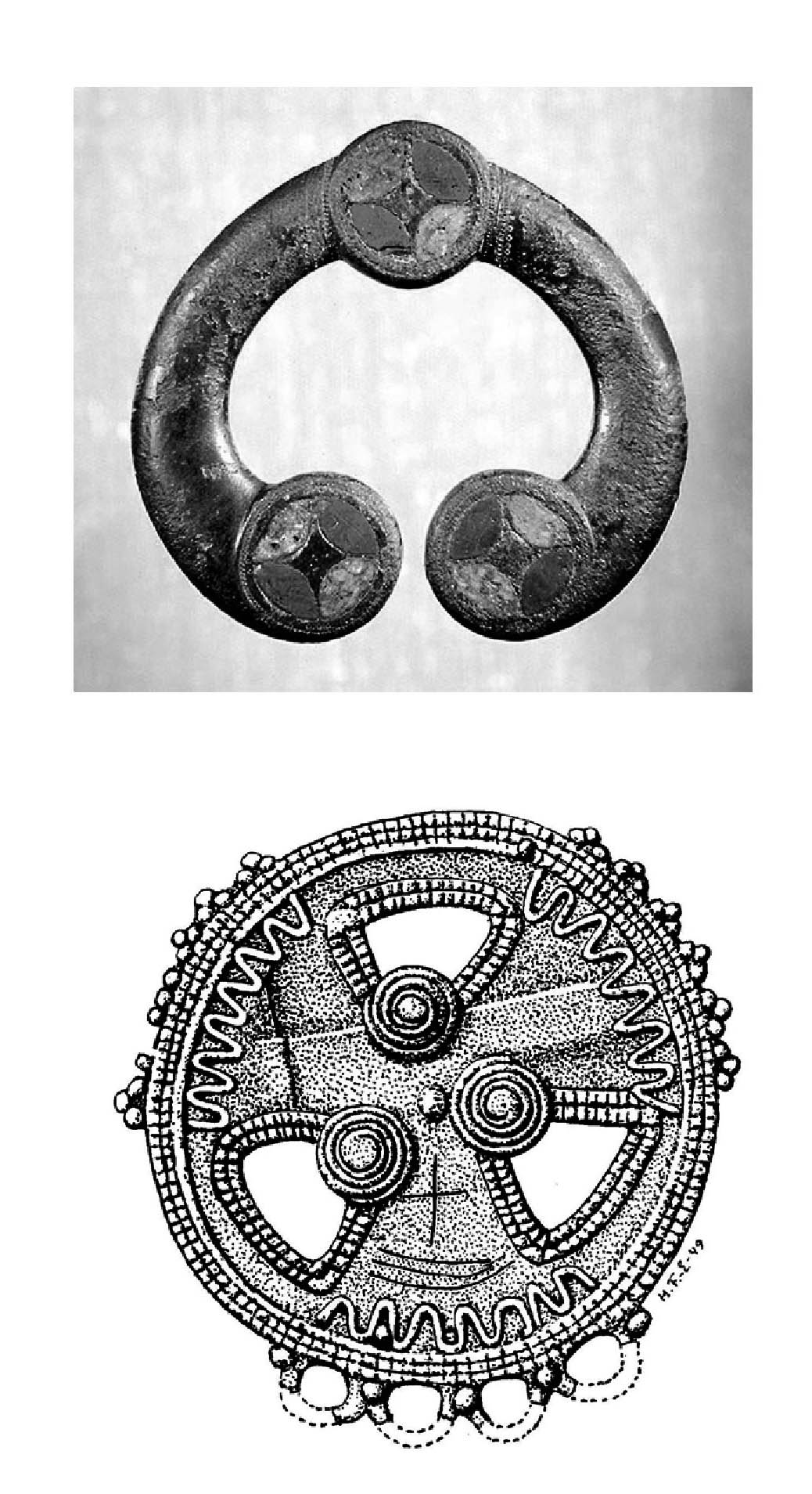
A few remarkable finds of isolated instances of eastern objects from the Mid-Iron Age have been found on the western shores of the Baltic. One is definitely of Roman Iron Age and Estonian origin and found far from it, at Storkåge in Swedish Västerbotten. They may serve as examples of such finds throughout the past. Their maritime meaning is nebulous, but a sailing ship has in fact been carved (outlined) on the object of the most distant origin, the Finna brooch of Ångermanland, also found in Sweden, obviously of the tradition of the Oka/ Kama river area of north central Russia and presumably made a few centuries later (late Migration or Vendel/ Merovingian period).
There may have been many examples of ethnic interaction and meeting points for different groups in prehistory, but we have only fragments to refer to, and only in the literate age. At the root of Jutland where during the Viking Age Saxons, Frisians, Danes and Slavonic tribes met according to the present place-name material (e.g. Crumlin-Pedersen 1997, map p. 33). A somewhat similar situation is indicated by various medieval immigration processes in the south, some initiated by the political situation. One case is the occurrence of Slavonic place-names on the Danish island of Falster. We also know of Slavonic immigration on Bornholm. The unique vessel-handling site of Maglebrænde on Falster demonstrates details of different ship types and models with various backgrounds. This many-sided interaction could obviously influence shipbuilding. Whereas, the so-called Nordic shipbuilding techniques are fairly uniform in clinker style with iron nails, vessels built in the West-Slavonic part of the Baltic display various other characteristics (lower and flatter hulk shape, tree-nailed strakes), which may amount to an independent form. At the curious shipbuilding site of Puck in the Bay of Gdansk, we meet a mixture of both traditions.
In the social sphere, we discern traces of earlier endemic warfare, but less obviously influencing settlement. The first great weapon sacrifice from ca 300 BC at Hjortspring on the island Als in southernmost Denmark includes a unique boat, a large warrior canoe of 20 ms, made of lime-tree. The kind of elastic boatbuilding displayed by this vessel was thought to be unique until a related find of a thwart was discovered in 1991 in Hampnäs/ Själevad in Swedish Ångermanland, much further north. It was made of pine, and presumably local. It seems that this kind of boats were spread with the usual rapidity of “military” technology. However, a very basic form of these boats seem to conform well with boats depicted in rock art already in the Early Bronze Age (ca 1800 BC).
From the Late Roman Iron Age (from ca 200-400 AD) and forward, there are already signs that settlements are displaced further inland, which may have to do with the threat from marauders on larger clinker-built vessel of the Nydam type ca 300 AD. It was found together with another large weapon find in Denmark (with sacrifices in several stages at least from 250-500 AD). This idea was put forward by Erik Nylén on the evidence of Gotland, and the process of withdrawal from the coasts has probably been confirmed in certain areas of Denmark. There are certain indications in the Nydam finds and others during the same period of raids of Eastern origin, including Gotland.
The kind of warfare implied is that of chiefdoms, more or less equal in status which fight each other with plunder for redistribution in mind, and maybe also for enforced tributes. The relationship between many Iron Age societies, the outward appearance of which looks somewhat like this, is characterized by the British archaeologist Colin Renfrew as Peer Polity Interaction (PPI).
An example of this would be the background of the unique find of a mass grave in two boats at Salme in Saaremaa, Estonia. It dates to a period, 8th century AD, where semi-historical sources (Ynglingatal about the Uppsala dynasty, etc) refer to Swedish (Mälaren area: chiefdom or kingdom) maritime raids to collect tribute precisely in this area. A more “colonialist” attitude permeates the outdated work of Birger Nerman on contacts during this period, but it is certainly still of some value.
For almost the entire ship history of the medieval period, we possess an unparalleled work in Ellmers in 1972, but of course not exclusively on the Baltic. However, it would be a valuable contribution to the Stand der Forschung to bring that part up to date. A valuable overview of the early Middle Ages in the area is the tiny booklet with a lot of distribution maps by Müller-Wille from 1989.
Common histories?
Are there common histories? A very short survey was made in the keynote by way of maps of later periods, Middle Age to Early Modern Times.
During this time-span, we witness the successive replacement of the Scandinavian dominance in shipping with a raiding kind of type PPE by the forceful conversion and land-taking of the various Crusades and finally the trading near-to-monopoly of the German/ Wendic Hansa. Low German would for centuries have been close to a lingua franca in maritime and urban contexts around the entire Baltic, the only one that we know of so far.
Around 1300, we find the first sequence of points during a journey along the Swedish east coast by way of Finland to Reval/ Tallinn copied into the tax register (Jordebog) of King Valdemar Sejr of Denmark (1202-1241). As indicated by me, its structure may reveal the existence of local pilots. We have a few references on such specialists in the Chronicle of Henry of Livonia.
For the extent and dispersal of maritime trade in heavy goods we have, for instance, the Gotlandic baptismal funts of sandstone from the Klinte area (and to some extent other sculptures), which were exported to a large area mainly in the Baltic and to some extent outside of it, from isolated occurrences at Bruges in Belgium to Umeå in Västerbotten in the Swedish north as the extremes. Dendrology applied on shipwrecks outside the Baltic seem to point out what has already been indicated in few instances of textual evidence in e.g. England, that fairly large quantities of south Baltic oak were exported for such purposes and certainly others as well.
Textual evidence, unfortunately fragmentary, seem to reveal certain interesting facts on sailing in the Baltic. A note on the mappamundi map of Fra Mauro in Venice from AD 1458 tells us that maps and compass are not used in navigation in the Baltic, only the lead. However, during a slightly later period, ca 1500 AD, the sailing directory of Das Seebuch (Dutch/Low German) documents the existence of routes by way of large islands like Gotland in a variable pattern across the Baltic, however, clearly depending on the use of the compass.
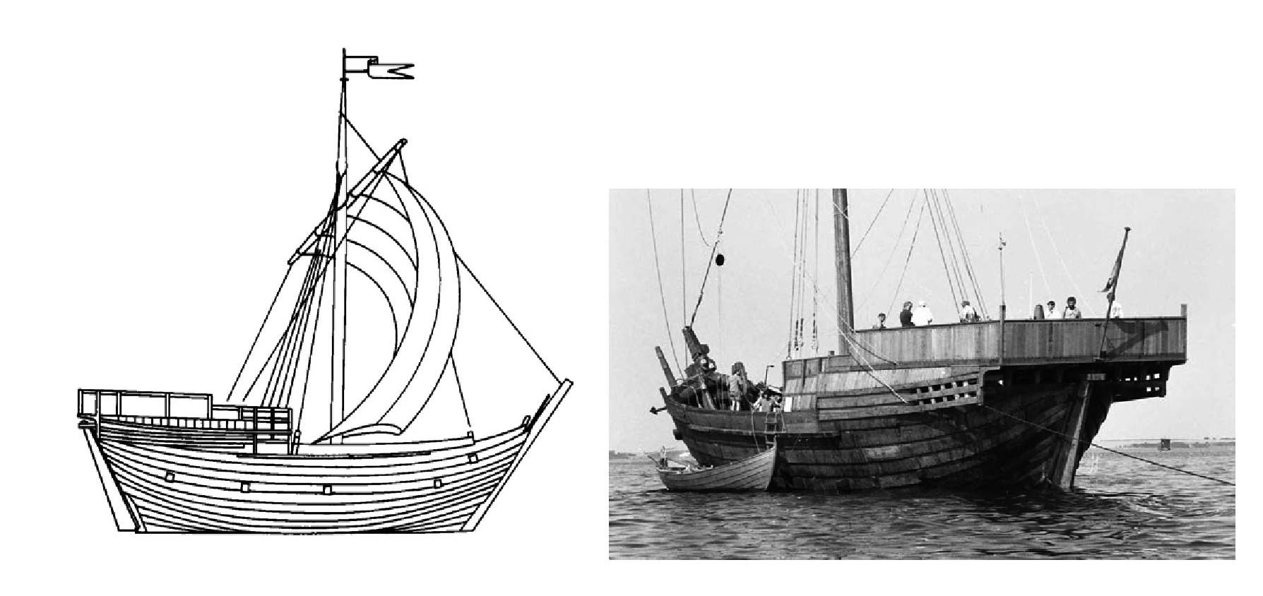
The dominant vessel type would be the cog/ die Kogge as the principal implement of the Hansa, often modelled in archaeological literature on that of the Bremen find (ca 1400 AD). The lure of the cog concept led recently to a particular designation “Baltic (type of) cog,” pinpointing above all two wreck finds in northern Germany: Gellen and Poel. The local pine curves indicated a dating at the end of the 14th century. However, recent research has shown that these ships belong to two quite different contexts. They were finally dated to the late 18th century, when Pomerania was still Swedish, and around 1840 both on South Finnish pine curves. The old-fashioned and partly cog-like features of these wrecks rather express the longue durée traditions of small-scale shipyards and peasant shipping. This fact would also point to a social interpretation of such tenacious technologies.
Parallel to the cog, a large variety of ship types must have plied the Baltic in this kind of small-scale traffic that should interest us in particular to redress the balance of former accounts. A fairly large shipwreck of another type, is that of the mid-16th century “Ringaren” (working name) from the eastern archipelago of Sweden (Tjust), the cargo of which seems to confirm trading contacts above all to the southern Baltic (Danzig area). Nowadays, there are several other finds of the whole period. A large material of shipwrecks has been discovered with invaluable new knowledge on ship building and cargoes. It has, as indicated before, become so large, that we are in need of a synthesis based on contextual variety.
If we want an epitome of the Late Middle Ages in the Baltic area we should turn to the illustrated ethnographic “map” of Olaus Magnus, the Carta marina (actually not his own name of it) of AD 1539. Of course, this is a patriotic expression made in Italy of a nostalgic Swedish exile, but his knowledge of the southern Baltic – he lived for ten years in Danzig (Gdansk) as a member of the Swedish Catholic expatriates - is unusually many-sided. This “map” should always be studied in its original size, which is quite large -to understand the details- not as an example of cartographic accuracy, which it is not.
If we also want an epitome of cultural contacts and eminent monuments of local identity, which illustrates a large bunch of Baltic prehistory and of its Middle Ages, we should of course look at Gotland. This large island in the middle of the main part of the Baltic has a unique mixture of cultural traits, doubly fascinating due to their preservation.
Ancient monuments on the coast
As to an example of coastal monuments of Baltic significance we could choose the coastal stone mazes. Their inception seems to be around 1300, but they were still laid out in the 19th century. Perhaps 600 of them are still extant, but clearly culture-specific in the Baltic, conforming to the medieval spread of Swedish-speaking fishermen-farmers in Sweden, Finland and Estonia. Otherwise, we find small clusters in northernmost Norway, obviously belonging to the Saami culture, and in the White Sea area, esp. in the Solovetsky Islands.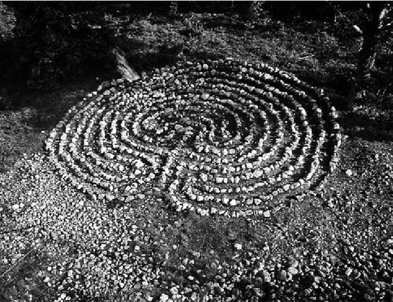
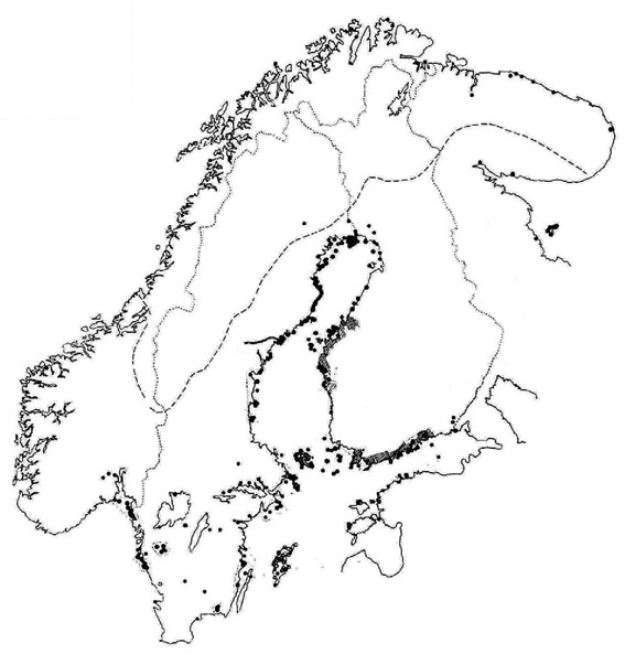 I believe that one of the motives behind stone mazes was already reflected by their other contexts: painted and carved in churches, laid-out on churchyards, and other places where burials were (or were believed) to be found (in the Visby case, close to the late medieval gallows). This motive would accordingly be the warding o of ghosts. Stone mazes are often found on islands, where unknown drowned people were buried permanently for the same reasons: an almost universal notion was up to our own times that ghosts could not pass water. Otherwise, the mazes were also used as instruments of universal fishing magic.
In fact, I have also compared the mazes in their possibly original function to the chapels placed at small harbour churchyards in the skerries, a typical occurrence in the maritime culture of Scandinavia and Finland.
Of course, we should also mention sea marks of which a few might be dated to the Middle Ages. However, most of these could be dated to the latest part, ca AD 1450-1550 and forward. In maritime matters, this era is marked by new economic and political processes, new ship types, and, concomitantly, partly different sailing routes necessitating new marks. According to my deliberations the inspiration (and sometimes the direct initiative) comes from the Low Countries and North Germany (the Hansa league). A number of important innovations in ship construction and sailing at this time and somewhat later: carvel-build, sprit-sail, stay foresail, bowsprit, rounded stem and stern (sometimes with comparatively at bottoms) the transom stern, keel with a rabbet - were also derived from Holland. Strikingly rapidly, these innovations filtered down to vernacular smaller vessels, including oar tholes with pins instead of the traditional hå. However, they were originally restricted to large-scale shipping and certainly not accepted everywhere, especially not in the north. Gradually, however, they became dominant. Social factors should never be neglected in the study of such changes.
The East
The port of Tallinn is situated between the West and the East, as is revealed poetically by the fact that its eponymous ancestors, Linda and Kalev reappear in the dominant place names for it in Scandinavia and Russia, Lindanäs and Kolyvanj. It could as well be a beautiful illustration to the general situation of the Baltic throughout history.
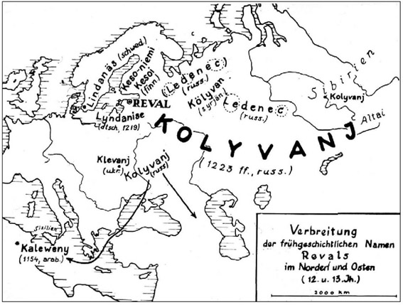
Hitherto, we have been talking mostly of the West. It is important to connect the Baltic perspective to the immense inland area of the east, to the Russian traditions of boat material and its rivers. In the very innermost north of the Baltic, we find traces of Carelian penetration of at least 13th century date along the inland river routes of present-day Finland (e.g. a trading post at Hietaniemi at the Torne river, Norrbotten Sweden). The northern part of the Baltic sea area together with North Russia is the last home of the traditions of the sewn wooden plank boats in Europe, apparently dissolving into Saami, Finnish and Estonian-Karelian-Russian subtraditions.
All through this area we meet the clearest proofs of portages between rivers and along rapids, already documented for the Rus Vikings by the Byzantine emperor Constantinos VII Porphyrogennetos (AD 905-959) between AD 948-952 along the Dnepr in present-day Ukraine. Traditions of expanded log boats and of various other techniques of making vessels in the East remain to be studied. Also the phenomenon of “intermittent travelling” in inland areas (with the vessel carried or dragged on the ground or in the water) is to be taken account of in other Baltic (and North Sea) contexts.
Summary
There is little but the spread of vessel technologies to illuminate actual contacts or interaction of a definitely maritime character, but dispersed glimpses of interaction and/or transmission between differing cultures do appear.
As to the traditional transport zones of the Baltic area I have suggested a generalized picture for the Iron Age and early medieval times.
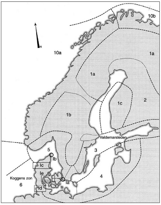
As to the cultural elements that could be deduced for the purpose of an overview of the past, I suggest very much a variety of different, more or less “culture-specific” divisions, but certainly in many cases overlapping:
Those which are common to the south and to the west.
Those which are common to the north.
Those which are common to the east.
That leaves a tiny common heritage, which is common to all of the Baltic, but these are at the same time mostly common to either the Scando-Baltic area, to the North Sea area, or to the whole of Europe.
This is the nature of an “international”, “interregional”, maritime culture, later sometimes creating new identities of its own. It is first apparent during the Viking Age and the Middle Ages c. 750-1500, and fully developed only during the following centuries.
Students of the Baltic need not feel inferior in maritime matters to the Mediterranean. Maritime ethnography was practically born here, its study of small-scale everyday maritime cultures or the diversities of vernacular ship and boat types is, I think, superior to its more prestigious rival. Probably this would go for their respective records of older maritime oral tradition as well. And the unique and enormous potential in the Baltic of the absence of the Teredo (at least for most periods) is beginning to show in earnest. However, so far not beyond the Middle Ages...
The very diversity of the Baltic Sea area through the ages is its greatest asset, posing unique questions of changes, of contact and lack of contact, maritime or not maritime in character.
Keynote lecture held in Tallinn in 2013 © Christer Westerdahl, 2021
